Great Britain was called Brittania, Scotland was called Caledonia and Ireland was called Hibernia.
Cities also had different names:
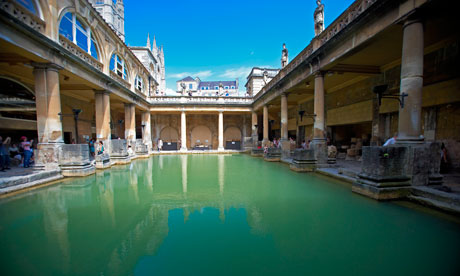
Dover was called ( Portus )Dubris, Bath was called Aquae Sulis, Edinburgh was called Cramond,
London was called Londinium, Glasgow was called Clotagenium, and Manchester was called Mamucium.
About some of these cities I will tell a bit.
Dubris was located near the river Dour, what made it an ideal port. Dubris grew into an imprtant Roman military fort, because ships could reach it easily over water.
When Caesar tried to invade Dubris, he was scared by the cliffs and sailed further until he reached an open beach. After he conquered the habitans of Dubris, he built there two lighthouses.
Cramond was a Roman fort with a natural port, because it was located at the river Almond.
The fort was build in 140 p.C., and it was used by the Romans until 170 when they retreated to Hadrian's wall.
In the river Almond near Cramond was a sculpture of a lion found, eating a man.
Clotagenium was a Roman legionary fort. It was build in 143 p.C., and had very thick walls of turf and clay, about 7.2 meter thick! Around the fort was a 10 meter long ditch, which was 1.2 meter deep.
The fort was meant to house only the ground troops, but was big enough to house the cavalry too.
Mamucium was a fort guarding the road between Chester to York. Mamucium was a Celtic name meaning
"Breast shaped Hill". Near the fort was a settlement of family and friends, which ended in a industrial activity.
The area around Mamucium changed greatly in a few centuries from a fort to a city in the Industrial Revolution.
Questions:
1. Which Roman emperor tried to invade Dubris?
2. What was found near Cramond?